

Avionics connection#
Air Navigation Pro is designed to seamlessly connect with a variety of onboard avionics systems from leading manufacturers such as Avidyne, Dynon and Garmin. This connectivity enhances the app’s capabilities by providing pilots with more accurate flight data, including GPS location, altitude and attitude. Additionally, it supports the sharing and management of flight plans.
Supported devices and capabilities#
The table below lists supported devices by manufacturer and the corresponding features available in Air Navigation Pro, helping ensure compatibility and optimal use.
Manufacturer |
Device Model |
GPS |
Attitude (AHRS) |
Pressure Altitude |
Flight Plan Sharing |
|---|---|---|---|---|---|
Avidyne |
|||||
IFD 410 |
✔ |
✔ |
✔ |
✔ |
|
IFD 440 |
✔ |
✔ |
✔ |
✔ |
|
IFD 510 |
✔ |
✔ |
✔ |
✔ |
|
IFD 540 |
✔ |
✔ |
✔ |
✔ |
|
IFD 545 |
✔ |
✔ |
✔ |
✔ |
|
IFD 550 |
✔ |
✔ |
✔ |
✔ |
|
Dynon |
|||||
SkyView |
✔ |
✔ |
✔ |
✔ |
|
Garmin |
|||||
GTN 650 |
x |
x |
x |
✔* |
|
GTN 750 |
x |
x |
x |
✔* |
Connecting to Avionics Devices#
To connect to a WiFi-enabled avionics system from Avidyne or Dynon and start receiving data in Air Navigation Pro, follow these steps:
Turn on the onboard avionics system
Go to settings and enable WiFi (most avionics have WiFi enabled by default)
In the WiFi section, find the WiFi name (SSID) and password
Open WiFi settings on the device running Air Navigation Pro
Select the WiFi network corresponding to your avionics device and enter the password when prompted
Wait for the confirmation message indicating a successful connection
In Air Navigation Pro, go to Tools > Sensors
Tap the manufacturer you want to connect to
Toggle the sensor ON to allow the app to use flight data from your avionics system
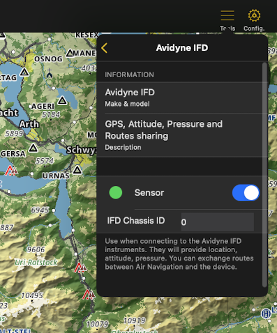
Note
For Avidyne IFD devices, you may need to specify the IFD Chassis ID (also known as the Sys ID), which can be found in the system menu.
Once successfully connected, it transmits GPS location, attitude and pressure altitude to Air Navigation Pro. While this data is also available from your device’s internal sensors, using an external avionics source offers greater accuracy, especially beneficial for features like the Synthetic View.
Exchange flight plans#
Air Navigation Pro supports bidirectional flight plan exchange with Avidyne and Dynon devices, allowing seamless sharing between the app and the connected avionics system.
Note
To exchange flight plans, the avionics system must be connected to the app and enabled as the sensor source. See the section above for connection instructions.
Depending on the manufacturer’s flight plan parameters, the supported route elements are as follows:
Airport
Fix
NDB and VOR
Significant point
Waypoint
User waypoint
Send a flight plan to the avionics#
To share a flight plan with a connected avionics system, follow the steps below:
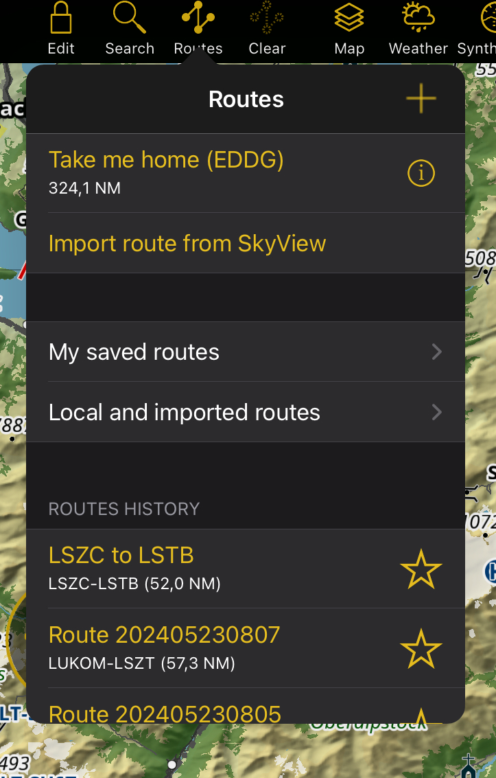
Open the Routes Menu by tapping the
 icon in the Tablet Menu Bar (for Mobile version, it’s located inside the Map Menu)
Navigate to one of the following folders: My saved routes, Local and imported routes or your Air Navigation Manager organization
Tap the
 icon in the top right corner
Route names will turn white, allowing you to select the routes you want to share (selected routes will be marked with a yellow checkmark)
Tap the
icon again and choose your connected avionics device as export option
You can also export your active route directly from the Navigation Dashboard.
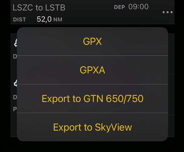
Once the route is shared, it will appear on the connected avionics system. When exporting to Dynon SkyView, the route is sent to the device’s FPL MENU. For Avidyne IFD devices, it appears in the ROUTE menu. Depending on the manufacturer’s settings, the route name and waypoint identifiers may differ from those defined in the app.
Note
Avidyne devices do not support routes with more than 128 elements. To share the flight plan successfully, you may need to reduce the number of waypoints.
Receive a flight plan from the avionics#
To download your active flight plan from the avionics system to Air Navigation Pro, open the Routes Menu and tap Import route from SkyView/Avidyne IFD. This option is available only when the app is connected to the avionics device. Refer to the section above for connection instructions. The imported route will be saved in the Local and imported routes folder and automatically set as active. See Route Management.
Share a flight plan to Garmin GTN#
Since Garmin GTN devices do not support WiFi connections, the only way to share a flight plan from Air Navigation Pro is by exporting the route as a file to an SD card. The app offers the option to export flight plans in Garmin’s supported format.
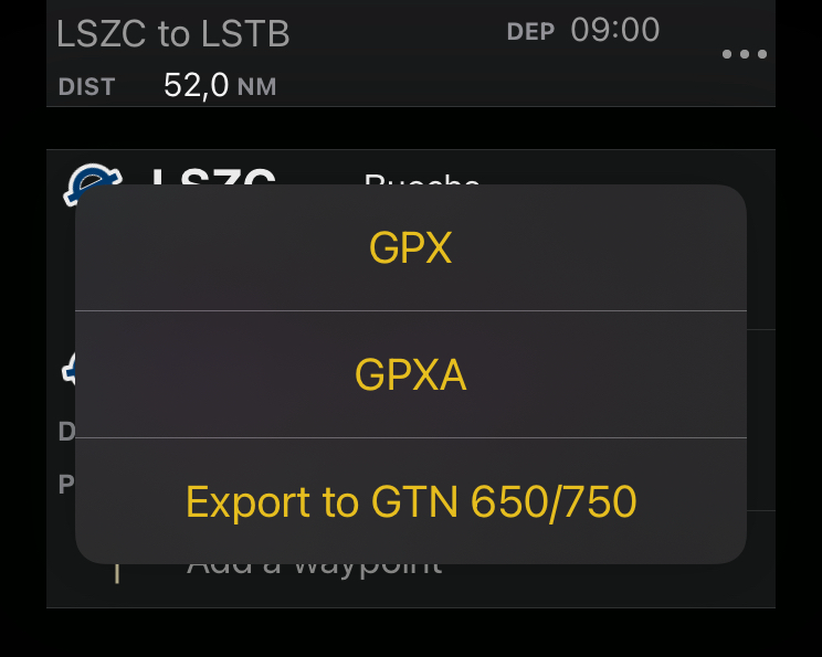
Tap
in the Tablet Menu Bar (for Mobile version, it’s located inside the Map Menu)Chooose the routes you want to export from one of the following folder: My saved routes, Local and imported routes or your Air Navigation Manager organization
Tap the
iconRoute names will turn white, allowing you to select the ones you want to share
Tap the
icon again and then select Export to GTN 650/750
You can also export your active route directly from the Navigation Dashboard.
The generated file can be stored locally, sent via email, AirDrop (iOS) or through any other sharing method available on your device. For more details, see Import/Export Data. The exported file follows the naming convention: <route_name>_name.gfp.
Note
Garmin GTN devices do not support routes with more than 99 elements. You may need to reduce the number of waypoints to successfully share the flight plan.
After inserting the SD card into the Garmin GTN device, the flight plan will appear in the Flight Plan Catalog menu under the Import option. A device restart with the SD card inserted may be required to view the file.
Important
The exported route file must be placed in a folder named FPL at the root of the SD card in order to be recognized by the Garmin GTN device.